

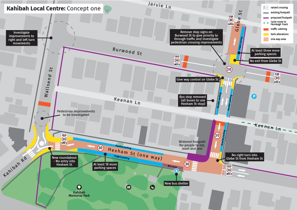
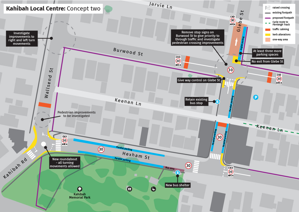
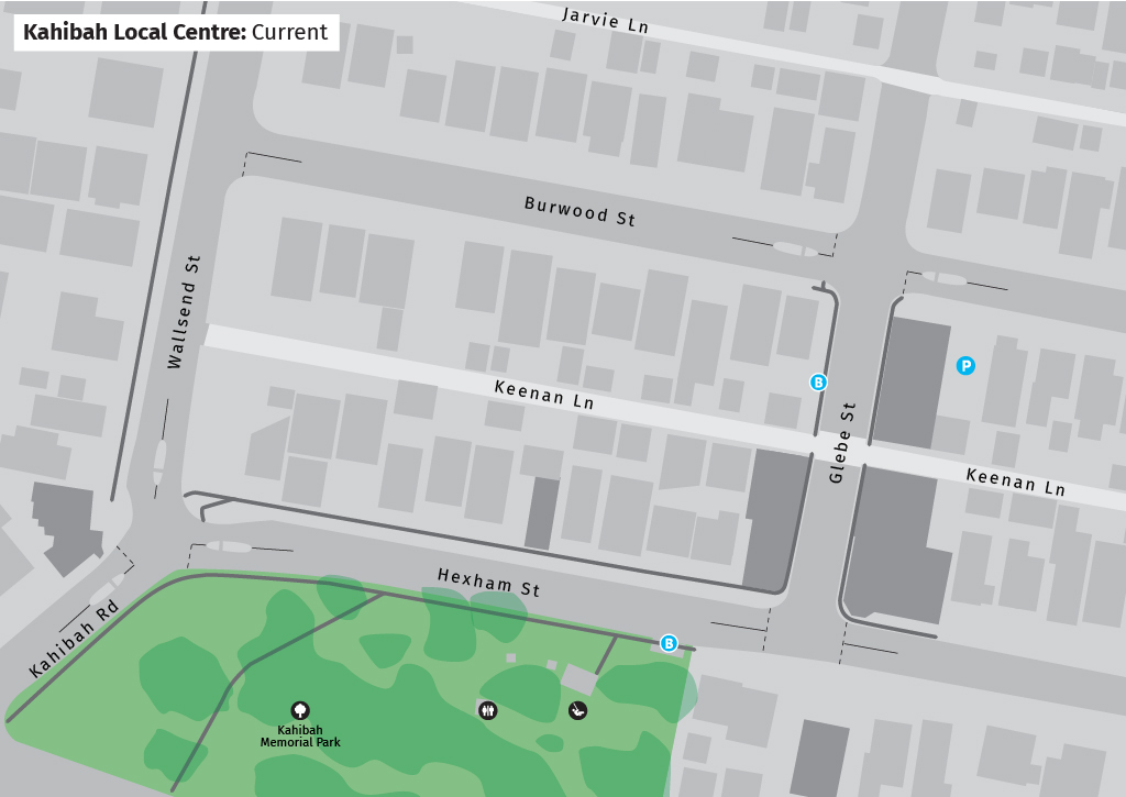
Council is investigating opportunities to improve safety, accessibility and traffic movement within the local centre. The concept designs aim to create a more connected, accessible and attractive area for residents, visitors and businesses.
Investigations have shown that treatments which would improve conditions at the intersection of Kahibah Road, Wallsend Street and Hexham Street may also affect surrounding streets, requiring Council to consider the precinct as a whole and carefully balance safety, transport network performance, amenity and cost.
The project responds to community feedback following a 2025 petition requesting improvements to pedestrian safety at the three-way intersection in Kahibah.
Council is seeking feedback on two concept options:
Option 1
- A roundabout is constructed at the intersection of Kahibah Road, Wallsend Street and Hexham Street.
- Vehicles can exit Hexham Street onto Kahibah Road or Wallsend Street but cannot enter Hexham Street from the roundabout.
- Hexham Street between Glebe Street and the roundabout becomes one-way.
- Through traffic in the local centre is reduced.
- Additional angled parking can be provided adjacent to Kahibah Memorial Park.
Option 2
- A roundabout is constructed at the intersection.
- All vehicle movements are maintained.
- Existing traffic circulation patterns are largely retained.
Both options include a 30 km/h High Pedestrian Activity Area on sections of Glebe and Hexham streets.
The concepts have been developed following consideration of:
- traffic modelling and operational assessments
- existing traffic volumes and vehicle movements
- road safety performance and identified risks
- pedestrian and cyclist movements through the centre
- site constraints and opportunities
- public transport operations
- parking demand and access requirements
- project costs and deliverability
- objectives developed to improve safety, accessibility, amenity and the overall function of the local centre.
A timeline of this work is included below:
| Timeline | Action |
|---|---|
| November 2025 | Audit of customer requests submitted between 2015-2025 related to road safety within the precinct |
| December 2025 | Road Safety Audit completed |
| May 2026 | Traffic speed, volume and pedestrian surveys undertaken |
| July-August 2026 |
Signage and line marking improvements completed Consultation with Keolis Downer and Transport for NSW |
| October 2026 | Residents consulted on proposed speed cushions at the intersection of Kahibah Road, Wallsend Street and Hexham Street |
| November 2026 | Speed cushions endorsed through Local Transport Forum and adopted by Council |
| November-December 2026 | Community consultation on broader local centre improvements |
The options being presented involve different trade-offs in terms of road safety, traffic movements, parking, bus operations and access within the Kahibah local centre.
Consulting before a preferred option is selected gives the community the opportunity to help shape the outcome and provide local knowledge that may not be evident through technical studies alone.
Community feedback will be considered alongside engineering, safety, transport and cost assessments before Council determines a preferred approach.
Yes. Council's Local Transport Forum has endorsed the installation of speed cushions on approaches to the existing intersection as an interim safety measure.
The speed cushions are intended to slow approaching vehicles, reduce crash risk, and improve safety for pedestrians crossing near the intersection.
Installation is expected during this 2026-2027 financial year.
Both options unlock additional parking within the centre.
Option 1
- Enables angled parking along Kahibah Memorial Park.
- Increases the number of available parking spaces in the precinct by at least 21 spaces.
Option 2
Generally maintains existing parking arrangements. Up to three additional parking spaces would delivered through this option.
Detailed parking layouts will be refined as planning investigations progress.
Both concepts include a proposed 30 km/h High Pedestrian Activity Area on:
- Glebe Street between Burwood Road and Hexham Street
- Hexham Street between Glebe Street and Kahibah Road.
The lower speed environment is intended to:
- improve safety for pedestrians and cyclists
- reduce the likelihood and severity of crashes
- support the operation of the local centre as a place where people walk between shops, services, the park and public transport.
Traffic surveys undertaken by Council indicate that most vehicles are already travelling at 25-35km/h within these streets, despite the current 50km/h speed limit.
Under Option 1, both northbound and southbound bus services would use the existing Kahibah Memorial Park bus stop location on Hexham Street.
Under Option 2, no changes to existing bus operations are proposed.
Council is working with operators to ensure public transport access is maintained with either concept.
Council understands local businesses rely on safe and convenient customer access.
As the project progresses to the delivery stage, we will work directly with businesses to minimise disruption.
This may include temporary detours and other traffic control measures to maintain safe access.
At this stage, no construction timeframe has been confirmed.
Both concepts have been designed with consideration of how traffic moves around the local centre and accesses local destinations.
Traffic modelling has been undertaken to understand potential changes in vehicle movements and to help ensure the surrounding road network continues to operate effectively.
Community feedback will assist Council in evaluating the advantages and disadvantages of each option as investigations progress.
The concept designs investigate opportunities to improve pedestrian crossings, footpaths, accessibility and traffic calming measures.
These improvements aim to make it easier and safer for people to move through the local centre.
Project costs will be developed as the project progresses and the preferred option is identified.
The project is expected to be funded in part by Developer Contributions.
The project is in the consultation phase.
Following consultation, Council will review feedback, undertake further investigations and determine next steps.
Construction of the selected option is currently unfunded within Council's adopted Delivery Program 2025-2029 due to completing priorities across the city.
The improvements will be considered for inclusion in a future Council Operational Plan.
Council’s approach to transport in Kahibah is guided by a vision and objectives developed to align with the Lake Macquarie Community Strategic Plan and Local Strategic Planning Statement.
Precinct vision
Kahibah Local Centre will be a welcoming, safe and connected centre that supports local businesses, brings people together, and provides easy access to schools, public transport, the Fernleigh Track and Kahibah Memorial Park.
The unique relationship between the local centre and the adjoining park and playground will define Kahibah as a vibrant destination where recreation, shopping and community life come together.
Kahibah Road and Wallsend Street will continue to serve as important east-west and north-south transport corridors, supporting the efficient movement of people, goods and bus services through the precinct.
As a gateway to the Fernleigh Track, one of Lake Macquarie's most significant active transport corridors, safe and convenient connections between the Kahibah and the track will establish the centre as a natural meeting place and starting point for active transport journeys, supporting residents to meet and access the Fernleigh Track while encouraging Fernleigh Track users to stop, visit and spend time in Kahibah.
Safe, accessible and conveniently located bus stops, together with intuitive streets, intersections and crossings, will support everyday travel and the significant number of school bus services operating through the precinct.
As the Charlestown–Dudley catchment continues to grow, Kahibah Local Centre will accommodate increasing travel demand through an integrated movement and place approach that enhances safety, accessibility and liveability while reinforcing the village character, strengthening connections to Kahibah Memorial Park, and supporting the long-term vitality of the centre.
Our objectives to the precinct are:
| Objective | We'll achieve this by... |
|---|---|
| Support a vibrant local centre by creating an environment that encourages visitation, social interaction and investment. | Increased opportunities for people to visit, spend time and support local businesses through improved accessibility, amenity, comfort and stronger integration between the centre and Kahibah Memorial Park. |
| Create a connected, accessible and comfortable active transport network that strengthens connections between the centre, Kahibah Memorial Park, public transport and surrounding destinations. | Improved walking and cycling safety, comfort and accessibility through connected routes, safe crossing opportunities, universal access and infrastructure that encourages active transport for people of all ages and abilities, while strengthening connections between the centre, Kahibah Memorial Park, the Fernleigh Track and surrounding destinations. |
| Improve safety for all road users while balancing through movements with place outcomes. |
Reduced crash risk and crash severity through the application of Safe System principles, lower vehicle speeds in high pedestrian activity areas, and safer interactions between vehicles, pedestrians and cyclists. The transport network accommodates local and regional travel demands while supporting a safe, connected and vibrant centre that prioritises people and place. |
| Reinforce Kahibah's village character through high-quality streets, public spaces and landscaping. |
Public domain improvements, streetscape enhancements and stronger connections between the village centre and Kahibah Memorial Park strengthen local identity and create an attractive and welcoming environment. Enhanced shade, comfort, biodiversity and visual amenity through additional planting and green infrastructure. |
